One of my hobbies is the study of old Los Angeles. Its buildings, its transportation systems, its way of life. I'm not exactly sure how this interest arose, but it has been pretty engaging.
An example is the presence of the JEMS building on a site just doors away from the old La Grande Station of the Santa Fe Railroad. It serves as an answer to the question, why is the street around the corner from us called, "Santa Fe Avenue?" In the photo below, the asterisk marks the current location of the JEMS building.
(Note: All photos in this post may be enlarged by clicking on the image).
(Note: All photos in this post may be enlarged by clicking on the image).

Anyone who has spent any time in downtown perceives the peculiar layout of the streets. Downtown Los Angeles is different from the rest of the city by virtue of its divergence from the norm of north and south running streets. In an LA Times article by D.J. Waldie, entitled "LA's Crooked Heart," Waldie pulls from different sources to explain the strange floorplan of the downtown sector.
A look at a closeup of a 1932 map shows this floorplan very clearly. (Please click on map to view an enlarged version).

Why is that section of the city canted in that direction?
According to Waldie and others before him, the tilt in the downtown area is an imprint of our Spanish colonial heritage. Long before the Americans "won the west," the area was founded by indigenous and later Spanish settlers. The layout of the city was based upon a 16th century organizational plan called the Laws of the Indies.
According to Waldie's article, the Laws of the Indies required that "the streets and house lots in the cities of New Spain have a 45-degree disorientation from true north and south to provide, it was said, equal light to every side of a small house throughout the day. Given the way Spanish and then Mexican Los Angeles extended along the bank of its uncertain river, only 36 degrees of compliance was possible."
According to Waldie's article, the Laws of the Indies required that "the streets and house lots in the cities of New Spain have a 45-degree disorientation from true north and south to provide, it was said, equal light to every side of a small house throughout the day. Given the way Spanish and then Mexican Los Angeles extended along the bank of its uncertain river, only 36 degrees of compliance was possible."
So while the city's heart was laid out by the old Spanish colonial plan, the rest of the city would come under the cartographic plan outlined by Thomas Jefferson. The Jeffersonian plan was intended to lay out a nationwide street orientation with north on top, south on the bottom and east and west sitting at right angles, except in cases of coastlines or mountains.
So although America conquered the west, it didn't conquer the heart of LA. The Jeffersonian plan begins west of Hoover and south of Santa Barbara (now MLK). North and east are a hodge-podge of mountains and neighboring cities, with no topographic ties to Los Angeles, per se.
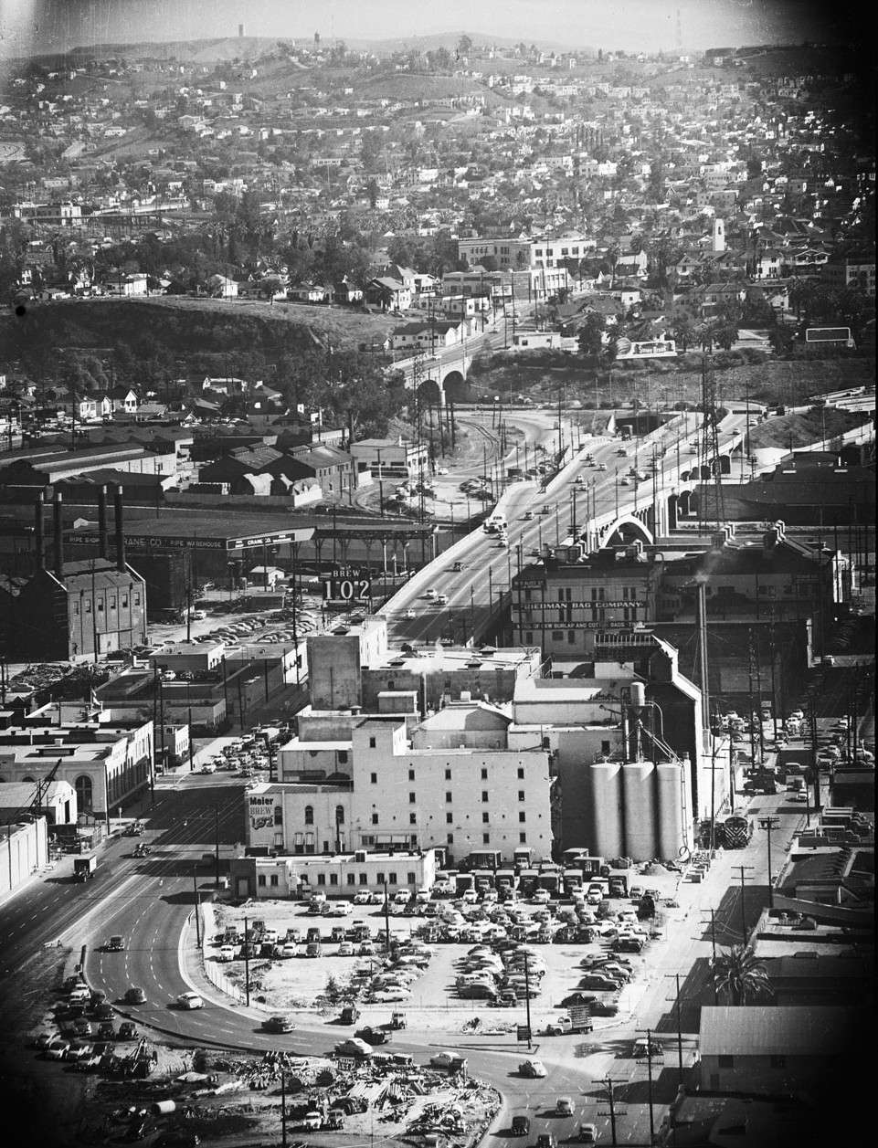
The downtown area has changed significantly. As a kid I can remember the Brew 102 building just off the 101 Freeway in the downtown slot. In fact, my dad got a ticket there once. When he told me that he "got pinched," I took him literally. I wanted him to show me where the cop pinched him.
The image below is taken of Aliso Street from the vantage point of City Hall. Aliso follows the route of the soon-to-be-built 101 freeway as it passes the Brew 102 building. Year: 1952.

From USC Digital Archive, but housed here:
http://img142.imageshack.us/img142/3543/la0521fromc1vbrewery.jpg
http://img142.imageshack.us/img142/3543/la0521fromc1vbrewery.jpg
Another photo of downtown faces the Civic Center with Brew 102 and the iconic gasholders that were featured as background in many old motion pictures. Early 1950s.

Source: USC Digital Archives.
Housed here: http://img687.imageshack.us/img687/4351/alisostreetviaductearly.jpg
Housed here: http://img687.imageshack.us/img687/4351/alisostreetviaductearly.jpg
Just below, a nighttime image shows part of the panorama of downtown, including City Hall and the gasholders.

Bringing this post back to South America, one of my favorite photos of early Los Angeles is one of Carmen Miranda in Pershing Square, selling war bonds for the US in 1943.

Credit: http://vickielester.com/2013/07/16/carmen-miranda-sells-war-bonds-photographed-by-ralph-morris/



No comments:
Post a Comment